Meteorview – new meteor visualizing tool
for the Global Meteor Network
Milan Kalina
Czech Astronomical Society, Ondřejov, Czech republic
milank2010@gmail.com
Abstract: A new tool for visualizing meteor trajectories, generated by the Global Meteor Network solver has been described. Various filtering and displaying options are thoroughly described including the screenshots. The new GUI allows to study all GMN meteor trajectories back to 2021, when the solver started to officially calculate and archive the data.
1 Introduction
There are a couple of tools for visualizing meteor orbits, produced by the Global Meteor Network (Vida et al., 2021), namely Tammo Jan’s Meteormap (Dijkema, 2022). After using this amazing tool for some time, I have decided to implement some new features, however, by using another platform, capable to process a larger amount of data. Finally, I ended up using SQL database, serving the panel/bokeh based engine on the external python hosting service, providing enough network bandwidth.
The application is available online[1].
Besides the meteor ground plots, the substantial addition is the radiant map, enabling to visualize selected data on the sky map and focus on the particular time or the sky map region of interest.
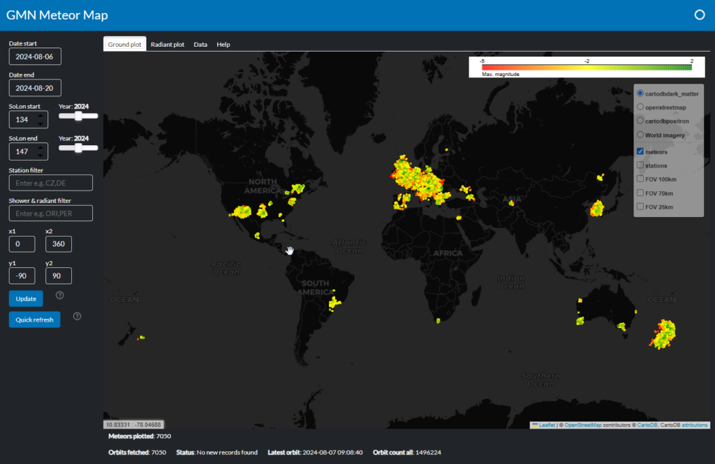
Figure 1 – Screenshot of the MeteorView visualizing tool.
2 Basic features
- All GMN data since 2021 available;
- Worldwide meteor ground plot with several basemap options;
- GMN station locations colored by a current status;
- Field of View (altitude of 100, 75, 25km) for each station;
- Filtering by date (solar longitude), station ID, shower, radiant coordinates;
- Radiant plot visualizing computed radiant, colored by selectable dimension;
- Rasterize option for large data display.
3 Background operation
The Meteorview meteor database is instantly refreshed by pulling the data from the GMN server, to keep up-to-date information about:
- Calculated orbits;
- Station list – add new stations if needed;
- Station status – displayed color determines the station status;
- Station FOVs at 25, 75 and 100 km.
Periodically, the Meteorview updates the all the camera station status, which is then used by coloring the station marker.
4 GUI description – Ground plot
When the main page is loaded, the date and time of the last calculated meteor/orbit is determined. The meteors of the last 2 days are loaded, by default.
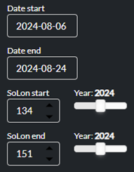
Figure 2 – Time interval selection.
The beginning and end date can be customized, either by the calendar widget, or by a solar longitude selection. Upon a change, the corresponding control is updated.
Data can be filtered by a station and shower name, both by a pattern, consisting from a few leading characters, separated by a comma.
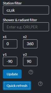
Figure 3 – Selection of station(s) and/or meteor shower(s).
In addition, the filter can be furthermore enhanced by radiant coordinates (in units currently selected on the radiant tab).
UPDATE button – simple submitting the above parameters.
Quick refresh button – instant download of the last 2 daily summary files from the GMN server, adding them to the database.
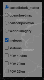
Figure 4 – Selection of map and objects.
There are a few basemaps available as a background. These can be used for various purposes, providing optimal brightness and contrast, when rendering the meteor ground plots and FOV polygons.
Meteors, station markers and FOV polygons can be switched on/off as independent layers. FOV polygons for each station are generated for heights of 25, 50 and 100 km above the ground.
Meteors are plotted as lines, colored by an apparent magnitude, starting from 2 (green) to –5 (red).
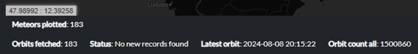
Figure 5 – The status bar.
The status bar displays some valuable information:
- Coordinates of the mouse cursor;
- Total number of meteors shown on the map;
- Current status of the last GUI action;
- Latest orbit calculated by the GMN solver3;
- Total number or orbits since 2021.
There are a few features, linked to the users’ mouse action.
- Mouse over – depending on the object, some corresponding information is shown:
- Meteor – date & time, shower code, peak magnitude, list of stations;
- Station marker – station ID, when last seen by the GMN server, status description;
- FOV – station ID.
- Mouse click:
- Meteor – detailed information, including orbit parameters;
- Station marker – station ID and a link to a corresponding GMN weblog.
A mouse click elsewhere on the map returns the station list, covering that point on the map, using the FOV polygons at 100 km height. This is useful especially in order to find out which stations could have recorded the meteor spotted at that location. The coordinates of that point are shown next to the station list.
5 GUI description – Radiant plot
The radiant plot is another kind of plot. Unlike the ground plot, it is displaying the sky map along with meteor/orbit markers positioned according to their calculated radiant coordinates.
The meteors are colored by a dimension, selected on the left side selection bar. By default, this is the meteor shower, as shown in Figure 6. The color palette is randomly generated.
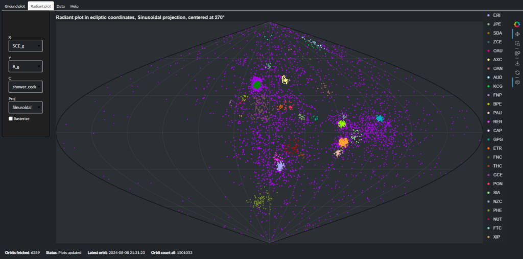
Figure 6 – The radiant map with the selection bar at right and color coded meteor showers at right.
On the left-hand side in Figure 6, there is a selection bar.
The units used for the sky map coordinates (X, Y) can be the geocentric Sun-centered ecliptic coordinates (default), Sun-centered heliocentric ecliptic coordinates, or simple geocentric equatorial or ecliptic coordinates. A diagram with longitude of perihelion Π, against inclination i or eccentricity e is also possible.
The C is the dimension used for the Z-axis (coloring). There is a number of continuous dimensions available, the default is categorical (shower code).
There are two projections available – sinusoidal (equal-area, default) or the Platecarree (equi-rectangular). Both projections exhibit different (dis)advantages.
The radiant plot is capable to process large amounts of data. In order to utilize the full display capacity, the Rasterize option dramatically decreases the marker size, to make the large data display possible.
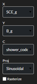
Figure 7 – The selection bar for the radiant map.
The bar on the right enables to switch on-off the controls on the radiant plot:
- Pan;
- Box zoom;
- Mouse wheel zoom;
- Save the plot as a picture;
- Undo;
- Hover on/off.

Figure 8 – Switching on and off controls.
Similar to the ground plot, a simple mouse over shows some basic information about the meteor/orbit.
6 GUI description – Data
This tab contains the simple paged table of data, as they were extracted from the database by a given filter. The button below can be used to download them as a CSV text file.
7 Backend details
The core of the application is Panel, part of the Holoviz open-source library, featuring the Folium map. The data is stored in the SpatiaLite database.
The code runs on the dedicated python hosting, using the NGINX server and a balancer.
The source code is available online[2].
This project is not maintained on the daily basis.
I appreciate any suggestions regarding the features and bugs, or even a pull request.
References
Dijkema T.J. (2022). “Visualizing meteor ground tracks on the meteor map”. eMetN Meteor Journal, 7, 73–75.
Vida D., Gural P., Brown P., Campbell–Brown M., Wiegert P. (2019). “Estimating trajectories of meteors: an observational Monte Carlo approach – I. Theory”. Monthly Notices of the Royal Astronomical Society, 491, 2688–2705.
Vida D., Šegon D., Gural P. S., Brown P. G., McIntyre M. J. M., Dijkema T. J., Pavletić L., Kukić P., Mazur M. J., Eschman P., Roggemans P., Merlak A., Zubrović D. (2021). “The Global Meteor Network – Methodology and first results”. Monthly Notices of the Royal Astronomical Society, 506, 5046–5074.
