FIREBALL OVER N-W ITALY
30 October 2016
This big fireball appeared at 17h34m41s UT of 30 October 2016 at the sky above the Ligurian Sea.
At that time in central and northern Italy the nautical twilight was already finished, the Sun was at -17° below the horizon in the north-east and at -14 ° in the north-west. Due to the evening hour and to the brightness of the meteor, there have been many visual witnesses, mainly occasional.
The fireball was reported also visually by many people from France and Switzerland through the IMO fireball platform.
All IMG-UAIsm [1] video cameras were operating, being already active as soon as the Sun reaches -8 ° below the horizon.
Five of IMG video cams captured the fireball completely or partially: BILBO (Figure 1) and STG38 (Figure 2) from north-west, NOA38 (Figure 3), MET38 (Figure 4) and ROVER (Figure 5) from north-east Italy:
– NOA38 cam, 45.56°N 12.11°E (obs: Enrico Stomeo)
– MET38 cam, 45.41°N 12.37°E (obs: Maurizio Eltri)
– ROVER cam, 45.86°N 11.00°E (obs: Fabio Moschini)
– BILBO cam, 44.55°N 9.04°E (obs: Stefano Crivello)
– STG38 cam, 44 .55°N 9.04°E (obs: Stefano Crivello)
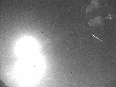 Fig. 1
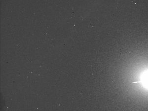
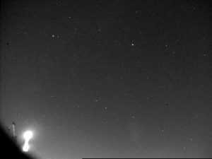 Fig. 2-3
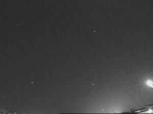
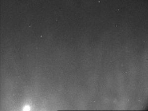 Fig. 4-5
Even a photographic image (Figure 6) has been received from central Italy (from Lago Trasimeno (PG), 43.14°N 12.16°E, obs: Milena Pieri).
Three useful observations were selected from the Italian visual reports, including informations about the firaball appearance:
– Report from Casole d’Elsa 43.31°N 11.14°E (obs: M.Cabibbo)
– Report from Verona 45.47°N 11.02°E (obs: M.Viviani)
– Report from Pontedera 43.66°N 10.65°E (obs: C.Casola).
Most of the observations from France and Switzerland were not very useful, because these were too inaccurate or affected by errors due to the large distance.
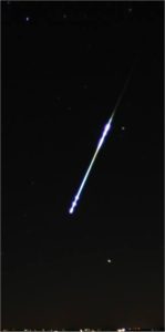 Fig. 6
 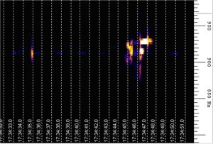 Fig. 7
The fireball was also recorded by the radio station located in Venice Planetarium (45.416°N 12.376°E).
Figure 7 shows graphically the persistence of the radio signal transmitted on the frequency 143.05 mHz from the Graves radar. The pulses were mirrored landwards by the atmospheric layers, ionized by the meteoroid.
The map in Figure 8 shows the projection on the ground of the atmospheric path of the fireball above the Ligurian Sea and the shooting visuals from individual stations.
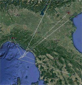 Fig. 8
Calculations were performed with IMG team software. Only the triangulations with high convergence angles and with low speed differences have been selected.
In the images below (Figures 9-10-11-12) the geometries of the atmospheric path of the fireball as seen from the north, east, west and south are indicated.
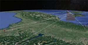
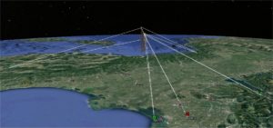
Fig. 9-10
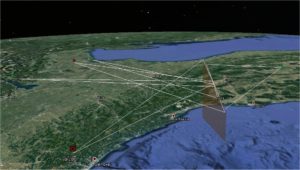
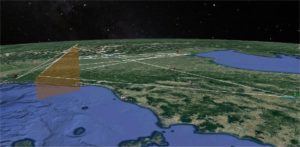
Fig. 11-12
The best circumstances occurred for BILBO and STG38 cams, which were closer and with direction almost perpendicular to the plane of the meteor.
Combining the photographic data available, it appears that the meteoroid began to be visible in the atmosphere at an elevation of 92.3 km and ended at about 38 km height, after a sequence of explosions and spectacular flares, clearly visible in the video captured by BILBO [2].
All the atmospheric path was situated above the Ligurian Sea from 43.91°N 9.90°E to 43.79°N 9.43°E, just south-west of the city of La Spezia,.
The most likely values, which describe the atmospheric trajectory and the heliocentric orbit of the meteoroid are summarized below:
– Observed radiant (eq.2000): RA 9.0° DECL +44.9° (Andromeda)
– Geocentric radiant (eq.2000): RA 14.0° DECL +43.9°
– Vobs: 18.8 km/s Vg: 15.1 km/s Vh: 34.8 km/s
– a (ua): 1.54 q (ua): 0.778 Ecc: 0.494 Peri(°): 249.8 Node(°): 217.5 Incl(°):15.3 (eq.2000)
Figure 13 shows some of the meteoroid orbits resulting from the better triangulations.
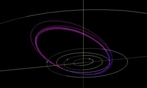 Fig. 13
Notations:
[1] Italian Meteor Group – UAI-Meteor Saction: http://meteore.uai.it
[2] http://meteore.uai.it/b2016/20161030_173441_bilbo.mpg
